Fuzzy and relative places in KML 2
I've got more (previously) half-baked thoughts on handling the fuzziness or relativity of places and their locations in KML. There are two sides to this issue: 1) a interface based on visual metaphors and hypertext through which a user can navigate fuzzy waters, and 2) an encoding of the fuzziness so that a machine can make sense of it when user-modified KML is uploaded.
One possible user interface is driven by HTML anchors and links to other KML entities within Feature descriptions [reference]: http://sgillies.net/files/relative2.kml.
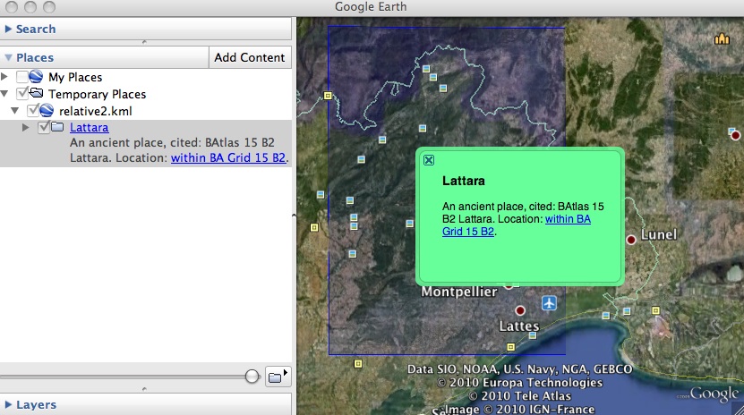
In this KML there is a representation of a place (labeled "Lattara") with a location that is known only from a gazetteer (in the back of my atlas) to be within the earthly footprint of the Barrington Atlas map 15 grid cell B2. The location of ancient Lattara is actually well known (and the museum dedicated to it in Lattes is a must-visit), but let's imagine it is not, and until I reconcile Pleiades with a big batch of updates coming soon from a partner institution, many of our places are in this state: known only to be within a lat/long rectangle. A nice feature of our model is we can identify places by URI without knowing their locations or coordinates precisely. The spatial data is added as we get it. You'll recognize that this is absolutely not the GIS way of doing things.
The simple place browsing user interface that surfaces in Google Earth from relative2.kml isn't terrible: click on the "Lattara" folder in the left pane and we get a free floating popup with a link to a location.
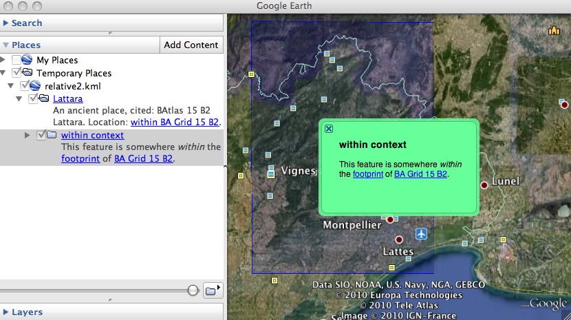
Click that link and we traverse to the location, which has more links to its spatial context.
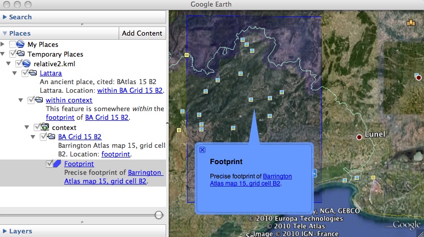
Click on the "footprint" context link and we get an anchored popup.
By representing the fuzzy location as a KML Folder containing a NetworkLink, my intention is better expressed in Google Maps than previously [map]. Every item of interest shows up in the pane on the left. Unfortunately, there are still no free floating popups for the "Lattara" and "within context" items. It's quite possible that I'm missing something, but it looks like Google Earth and Maps behave differently. A close look at the DOM of a Maps page post-load shows that there's no snippet div to be shown in a popup for item that's not a placemark.
I think what I need is way to represent the "within" relationship (or others) as a placemark – and this is where the issue (2) of machine readability comes up – without asserting that its position in the map marks the actual location of a place. Maybe KARML's balloons aren't as far off the mark as I thought. A problem with them (for me) is there's no way to create them from Google Earth. Not much of a KML editing tool, Google Earth doesn't even let a user create "extended data", but it's ubiquitous. I am very much trying to avoid having to write a one-off visual editor for fuzzy and relative locations. I've got enough on my plate already and would like to find a fairly generic and declarative solution: location relativity expressed in markup, not written into a database using a specialized API or specialized GUI.
What to do? RDFa in Feature descriptions ala
<description><![CDATA[
This feature is somewhere within the
<a
  rel="where:within"
  href="http://sgillies.net/files/bagrid15.kml#batlas-15-b2-footprint;balloon">
footprint</a>
of
<a href="http://sgillies.net/files/bagrid15.kml#batlas-15-b2;balloon">
BA Grid 15 B2</a>.
]]></description>
is a possibility. Of course, you can't count on users to type RDFa and HTML properly (to change rel="where:within" to rel="where:outside" for example), so this opens a very large can of worms.
I'm going to continue to think aloud about this for a while. Good ideas and good-natured heckling are welcome.